What's New
Bug fix...
Bug fix...
Size:
14.7 MB
Category:
Travel
Travel
OS:
iOS
iOS
Price:
$24.99
$24.99
Compatible:
iPhone iPad
iPhone iPad
Requirements:
Requires iOS 4.3 or la
Requires iOS 4.3 or la
Version:
15.0.0
15.0.0
Description - Marine Navigation - Germany - Inland Rivers / Canals - Marine/Nautical Charts
.
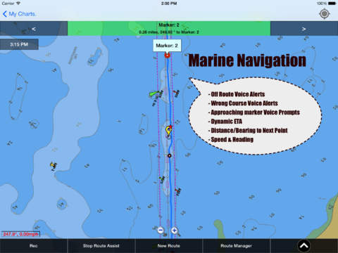
record marine gps tracks. found in 1 reviews
alerts when boating in wrong direction. found in 1 reviews
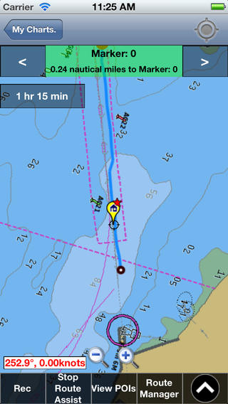
continous distance and eta updates. found in 1 reviews
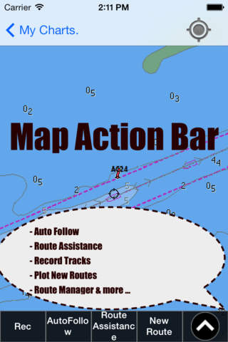
seamless chart quilting of marine charts. found in 1 reviews
visually draw area to download. found in 1 reviews
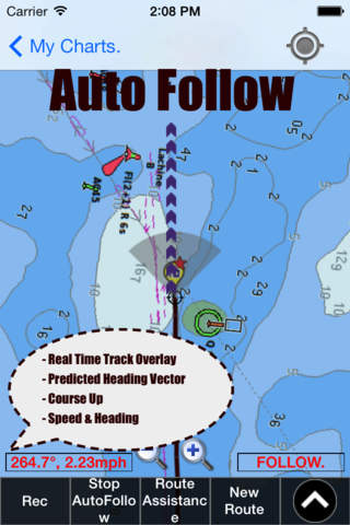
continuously updates boat's location on chart. found in 1 reviews
pan zoom my location. found in 1 reviews
com main folio catalog nautical charts app for complete list. found in 1 reviews
export gpx tracks. found in 1 reviews
track analytics stats. found in 1 reviews
auto follow mode course up. found in 1 reviews
export to sdcard. found in 1 reviews
edit existing gpx kml routes. found in 1 reviews
route editing creation. found in 1 reviews
live track animation. found in 1 reviews
select point on map. found in 1 reviews
longitude coordinates. found in 1 reviews
If you are iPhone and iPad owner,you now can download Marine Navigation - Germany - Inland Rivers / Canals - Marine/Nautical Charts for $24.99 from Apple Store. The application is supporting English language. It weighs in at only 14.7 MB to download. The new Marine Navigation - Germany - Inland Rivers / Canals - Marine/Nautical Charts app version 15.0.0 has been updated on 2014-02-13. For ensuring consistency with the device you should take into account the following app compatibility information: Requires iOS 4.3 or later. Compatible with iPhone, iPad, and iPod touch. This app is optimized for iPhone 5.
More Info: Find more info about Marine Navigation - Germany - Inland Rivers / Canals - Marine/Nautical Charts in Bist LLC`s Official Website : http://gpsnauticalcharts.com
More Info: Find more info about Marine Navigation - Germany - Inland Rivers / Canals - Marine/Nautical Charts in Bist LLC`s Official Website : http://gpsnauticalcharts.com
GPS Marine Charts App offers access to charts covering Germany (derived from BSH(Bundesamt f r Seeschifffahrt und Hydrographie) data) with POI layers created from ENC charts. Only marine GPS app to have route assistance with ...
Boating for 50 years Including one single handed circumnavigation using sextant only Professional Alaska fisherman for 43 years Have used Garmin Navionics C Map and others This is the worst Don t waste your money Way too complicated and poorly arranged menus Tried Europe and Germany Information even when found was poor at best Bill Capt Bill stacyanna21
Boating for 50 years Including one single handed circumnavigation using sextant only Professional Alaska fisherman for 43 years Have used GarminNavionicsCMap and others This is the worst Dont waste your money Way too complicated and poorly arranged menus Tried Europe and Germany Information even when found was poor at best Bill Capt Bill
By Kostas Gar.